

Sunday 22nd March 2015, Start 10:15am
Click Here to Enter Online
Information about the Race
This event is to take place along side the Gin Pit marathon and is the first half of the marathon course.
Much of the first part of the course runs along the trails created by the disused railway lines from our industrial heritage before returning along the Bridgewater canal.
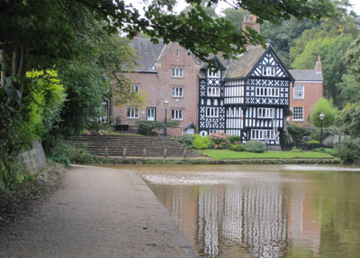
Look out for the picturesque village of Worsley at 9 miles, with its beautiful black & white mock Tudor buildings contrasting with the unusual orange canal water. At 11 miles you will pass through the village of Astley where the coal mine’s pit head still remains. Its iron work & wheel stand proud above everything else as a lasting reminder of the industry that used to overwhelm the whole area.
The beauty that has come out from the coal dust of the industrial revolution can be enjoyed by those of us willing to leave the roads behind to explore and probably get muddy!
Road trainers are suitable for dry conditions but trail shoes are recommended in wet conditions as the course can be very muddy in places along the canal through Boothstown and Astley.

The race starts at the Miners Welfare Club, Gin Pit Village, Ley Road, Tyldesley, Manchester, M29 7DW. The finish is on the Bridgewater canal at Marsland Green Bridge in Astley. There is a 1 and a half mile walk (or cool down jog) back from the finish to the Miners Welfare Club.
Please do not enter the Welfare Club in muddy trainers and running gear, please respect our club house.

Race limit is 50 runners.
There is a 3 hour time limit.
Minimum age 18.
Medals to all finishers. Trophies for first male and female. Plus other prizes.
Entry Fee £14.00 attached or £16.00 unattached. Strictly NO entries on the day.
This race is included in the A&T Road Champs.
 Trail Running Association Permit no. TRA/08-15
The event is held under UK Athletics rules.
Race start time 10:15am.
Pre-race registration and collection of race numbers will be from 9am at the Welfare Club next to the start.
Maps and directions will be available at registration.
Parking, toilets and a bar are available at the Welfare Club. Hot drinks and pasties will be on sale after the race.
There is only one water station at the 7.85 mile point as the course turns onto the canal & there will be jelly babies, biscuits & water available. The course is not marshaled but is marked with signs and yellow arrows. Directions and maps will be available at the start but these are not essential to navigate the course.
Any updates will be posted on this webpage and the A&T Blog.
Click here to download the Half Marathon entry form
Click here to see March 2015 confirmed entry list
Click here to follow a link to a map of the course
Click here to download a map of the course
Click here to download course directions
The directions have been created as a word document so that competitors may alter it to fit their individual needs, for example increase font size to make it easier to read while running.
Click here for March 2015 results (after the race)
For runners’ RACE DAY and Safety Information please click here.
For a copy of the event’s risk assessment, click here.
For runners looking for medial advise please follow the link to the Runners Medical Resource Website.
Recommended kit
Equipment:
Directions (available at the start of the event)
Garmin (will work well in conjunction with the directions)
Clothing:
Hat and gloves
Waterproof top
Long sleeve top & leggings
Trail shoes for wet conditions


